
The WOC Long Distance takes us again to Neulaniemi, where orienteering turns into a game of strategic navigation, endurance, and constant decision-making. In this third episode of our Road to WOC series, we focus on the key demands of this year’s long distance, with insights from the reigning world champions in the discipline, Simona Aebersold (SUI) and Kasper Fosser (NOR), and a special contribution from the mapmaker Janne Weckman (FIN), one of the two men behind the cartographic work in Kuopio.
Let’s dive into what it takes to master the challenge.
🗺️ The Terrain: Familiar, but More Demanding Than It Seems
We’re back in Neulaniemi, yet the demands of the long distance shift the focus dramatically compared to the middle. The physical and mental load increases, and maintaining high-speed navigation under fatigue becomes the main battle.
The forest is predominantly coniferous with variable runnability. There are sections with clean, fast undergrowth, but many areas demand careful attention to vegetation changes, fallen trees, and diffuse features.
As mapmaker Janne Weckman explains:
“The forest is mainly old, so the vegetation boundaries are not as clear as typically in Finland. There are more fallen trees, and sometimes it’s hard to say if those should be on the map or not. Small paths near the city can change surprisingly fast too. So, there are maybe a bit more places where different mapping decisions could be taken compared to the typical Finnish forest. Still, the map will be good and according to ISOM 😁.”
Here are the core technical challenges athletes will face, based on elite experience and deep terrain analysis:
🔁 Micro route choices: Proactive decision-making
In long distance, each leg requires a plan, and sometimes even a micro-adjustment within the leg. The terrain offers both fast and slow areas—reading the terrain speed and adapting the line is essential.
💬 “In this kind of terrain, it’s most of all about finding the fast lines,” says Simona Aebersold.
“Seeing which parts are slow and worth it to run around is crucial to not lose seconds—but also the other way around: to see passages that are fast in the terrain.”
A successful runner will be proactive in finding those lines, even if they seem counterintuitive on the map. Being reactive, or “just following the bearing”, could be costly.
🧭 Compass mastery: Control in diffuse areas
There are many zones of low visibility, vague contours, and scattered or inconsistent objects. This demands very precise compass use to hold direction confidently through unclear ground.
🎯 Attack points and control precision
Don’t lose focus in the final meters of a leg. Seconds can bleed away inside the control ring due to hesitation or small misses.
Runners must:
- Choose clear attack points, even if they aren’t direct.
- Maintain map contact and tempo right to the control.
- Use composite interpretation: avoid trusting a single object; rely instead on a constellation of features to build a secure picture.
⚖️ Simplicity vs Safety
A key balancing act in the long is between simplifying the leg to maintain speed and selecting enough reference points to stay safe.
Simplifying too much? You risk a parallel error or hesitation.
Too much detail? You’ll slow down, overread, and burn energy.
Mastering this balance is what separates good performances from great ones.
⚠️ Avoid the traps
Several features could become “time traps”:
- Boulder fields
- Dense vegetation
- Cliffy or steep hillsides
These may look tempting to cross or cut through, but getting stuck or slowed down for 20–30 seconds can ruin even a well-executed route. Good athletes will know when to sacrifice the shortest line for the cleanest one.
🧠 Route strategy: Play the long game
Not every leg has to be won. Sometimes, saving energy for the next 30 minutes is smarter than pushing into a risky choice that saves 15 seconds.
💡 “Sometimes a good strategy in the long distance is choosing routes that are efficient and conserve energy, even if you are not going to ‘win the leg’,”
This is long distance at its finest: it’s not about perfection, it’s about accumulated efficiency over 90 minutes.
Now that we’ve explored the key concepts, it’s time to move from theory to practice.
As in our previous episodes, we’ll now take a closer look at two long distance-style route choice legs, carefully designed to reflect the type of terrain and decision-making that athletes will face in Neulaniemi. But before jumping into maps and options, pause for a second: How would you tackle a 10-minute leg through broken ground? Would you choose the cleaner line, conserve energy, or try to dominate with bold navigation?
Time to put yourself in the athlete’s shoes.
📍 Simulated legs from the WOC long distance
Below you’ll find two simulation legs that bring out the essence of long distance orienteering in Kuopio: legs where success depends not only on endurance and speed, but on your ability to read the ground, anticipate traps, and manage risk over time.
➡️ Your task:
Study the map. Draw your preferred routes. Don’t focus only on distance—evaluate runnability, climb, terrain features, and your attack strategy.


🧠 Think About…
- Scan the terrain to identify fast corridors—areas of good runnability where you can maintain momentum—and flag danger zones like boulder fields, dense vegetation, steep slopes,… that could break your rhythm or slow you down significantly.
- Compare options with a long-term view: is it smarter to take a flatter, longer line that conserves energy and reduces risk, or does the shorter, more technical route pay off despite requiring full concentration and precision over complex terrain?
- Consider when it’s worth using paths, trails or linear features to simplify navigation. They can offer flow and speed, but are you risking a difficult re-entry into the terrain or an overshoot near the control?
- Weigh technical challenge vs execution reliability: will you go for a sharper line that demands constant map contact, or opt for a more conservative route that allows for physical recovery and mental reset?
- Decide on your attack point strategy for each control. In areas with diffuse features or poor visibility, a solid attack point could save precious seconds and avoid costly mistakes.
- Prepare for terrain transitions. How will your navigation style shift when moving from vague, rocky zones to open forest? Can you adjust pace, focus, and map-reading accordingly?
📆 Stay tuned for more simulations, route challenges, and analysis all the way to WOC25. The forest of Finland is calling. Will you be ready?
SPOILER ALERT!!!
If you haven’t drawn your route yet, do not keep scrolling down!!!
The analysis of the routes is posted just below!!!
EPISODE 3 – ROUTE #1: SReading the Terrain, Beating the Slope

At first glance, this long leg might appear rather straightforward—an almost flat progression with a steeper climb only near the end. But a closer inspection reveals a far more intricate challenge: how to approach and cross the final slope efficiently.
This is not just a climb. The last third of the leg contains a steep hillside scattered with boulder fields and impassable cliffs, making poor route planning here a real trap. The runner must not only find a clean progression line through the first kilometer, but also plan exactly where and how to breach the slope, avoiding hesitation, slow footing, or getting stuck in chaotic terrain.
Adding to the complexity, the total climb ranges from 110 to 125 meters depending on the route—spread across 1.3 to 1.5 kilometers—making this a physically demanding leg that will punish inefficient execution.
Let’s analyse the different options.
Option A (1340 m / +110 m)
The Low Flow Line – RF-COACH route
This is the most leftward route, designed to maintain flow and speed by staying low and flat for as long as possible. It avoids the temptation of early paths or mid-leg climbs and instead seeks to navigate through open areas with few features, where the forest is expected to be clean and runnable. The final slope is tackled with a direct but calculated climb, entering through a zone of manageable slope angle and decent visibility.
➡️ This route requires good compass work and offensive navigation, as it lacks strong features. But if executed confidently, it offers a fast, uninterrupted line and avoids the riskier rocky sectors of the hillside.
✅ Technically clean and physically balanced. A solid, aggressive choice for confident runners.
Option B (1345 m / +115 m)
The Track-Boosted Classic – Choice of Simona & Kasper
This line follows a similar philosophy to Option A in its general trajectory but leans slightly closer to the line. The key difference is that it uses a stretch of track (≈200 m) mid-leg to increase speed and simplify navigation, before approaching the slope in a similar way to A.
🗣️ “I would run pretty much on the line until the path that goes up between the hills. From there I’d follow that path until it’s a bit nicer in the slope to cross the section with the cliffs and then attack the control from below.”
— Simona Aebersold
➡️ While slightly more physical and with minor detours through slower zones, the presence of a fast trail segment may allow better speed and smoother map reading.
✅ A very smart and race-ready option—favoured by world champions for a reason.
Option C (1350 m / +115 m)
The Direct Slope Gamble
This option starts straight and quickly shifts right to avoid the hill, aiming for a more direct attack on the control by squeezing between the boulder field and an impassable cliff. However, it climbs the slope in one of its steepest and most chaotic sections, where visibility, footing, and navigation are all severely compromised.
➡️ On paper it looks short and appealing. In practice, it demands high risk for questionable gain—a typical trap in long distance racing.
🚫 Not recommended. Too much uncertainty in a critical phase of the leg.
Option D (1400 m / +125 m)
The Safe Runner’s Detour
This route begins by diving further right, using roughly 400 m of fast path running, before merging with the line of Option B. It avoids early micro-navigation and could suit athletes looking for mental reset or pacing control. However, it introduces more climb and length, and its advantages are mostly psychological rather than tactical.
➡️ While it provides safety and rhythm, it’s likely slightly slower than the cleaner lines of A or B due to its detour and extra ascent.
🟨 Viable, especially for less confident runners—but not optimal at top speed.
Option E (1500 m / +110 m)
The Long Right Arc – Physically Safe, Strategically Weak
A radical choice that swings wide right, avoiding technical navigation and minimizing climb with a more gradual ascent. However, it spends much of its length in mediocre terrain with low runnability, and approaches the slope from a vague, less defined angle, making the control attack uncertain.
➡️ It might be physically less taxing, but adds too much distance and offers no significant strategic gain.
🚫 Uncompetitive unless you’re in survival mode. Poor visibility and unclear attack line hurt its chances.
Final Thoughts: Plan the Slope, Own the Leg
This leg is a textbook example of long distance orienteering: not just about finding the fastest ground, but about knowing when and where to take on the key challenge—in this case, the slope and its chaotic details.
📌 The main takeaway?
- A or B offer the best combination of flow, speed, and clean slope entry.
- A rewards offensive runners with control and rhythm.
- B, thanks to its track segment, adds stability and simplicity—making it the top pick for elite execution.
- C looks tempting but is tactically flawed.
- D and E provide “safe” alternatives but fail to justify their physical and strategic cost.
As we often say in long distance: the fastest route is the one where you never lose momentum, especially when facing the toughest parts of the leg.
EPISODE 3 – ROUTE #2: Offensive Navigation in Subtle Terrain
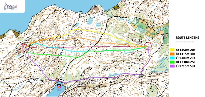
If the previous leg challenged athletes to plan when and where to climb, this one flips the script: flat terrain, diffused features, and continuous decision-making.
At first glance, it may look like a leg where “just running straight” will do—but in reality, this is exactly where elite-level orienteering is decided. The map may not scream danger, but the terrain hides subtle traps and opportunities. Runners must constantly adapt: switching lines, recognizing progress markers, and staying ahead of the terrain, both physically and mentally.
This leg will test a runner’s ability to be offensive, proactive, and precise in their navigation. There are no cliffs or major slopes forcing decisions. Instead, the key lies in how well one can identify clean corridors, maintain direction through vague sections, and avoid falling into hesitations or micro-mistakes.
Let’s break it down.
Option A (1350 m / +20 m)
The Wide Drift – Leftward and Loose
This is the furthest left route, starting with a clean enough corridor, but quickly moving into terrain that is diffuse and vague, with sparse features and vegetation patches that slow progress. The lack of structure in the second half makes it difficult to maintain flow and speed.
➡️ Technically possible, but offers too few navigational anchors to be efficient under pressure.
🚫 Likely to bleed seconds through hesitation. A suboptimal choice.
Option B (1315 m / +30 m)
The Midline Follower – Slightly Better, Still Risky
This line begins similarly to A, but stays slightly closer to the line, navigating through moderately runnable terrain with a few more recognizable features. It avoids the densest patches, but still suffers from diffused mapping and potentially slower terrain in the second half.
➡️ Better than A in terms of control, but still lacks the precision and structure offered by the top choices.
🟨 Acceptable, but unlikely to be among the fastest.
Option C (1300 m / +20 m)
The Smart Cut – Simona’s Route
A clean and clever route, this is the shortest of all, starting just right of the line. The beginning demands a short downhill to avoid a cliff, but from there, the line stays direct, threading between recognizable features and avoiding slow areas.
🗣️ “I’d run a bit to the right of the line, looking for nice and fast passages.”
— Simona Aebersold
➡️ Combines distance efficiency with clarity, giving the runner both speed and confidence. Requires focus, but highly rewarding if executed well.
✅ Direct, clean, and fast—one of the best options.
Option D (1330 m / +25 m)
The Structured Flow – Kasper & RF-COACH route
This route begins with a slight upward shift to gain access to a well-structured terrain corridor, including a 150-meter stretch on a wide path. It then merges with Option C in the second half, approaching the control through clear features.
🗣️ “In this forest it’s usually best to stay close to the line, look for the flat lines and avoid rocky areas.”
— Kasper Fosser
➡️ Perhaps not the shortest, but benefits from strong terrain structure, speed up on the path, and a direct, readable finish.
✅ Excellent blend of structure, speed, and safety. A champion’s choice.
Option E (1715 m / +50 m)
The Track Runner’s Escape
A wild outlier—this route swings wide to the far right, adding over 400 m more than the shortest lines. But in return, it provides over 60% of the leg on fast track, offering speed, low mental load, and a secure navigational route.
➡️ It’s not a top-10 option. But for runners aiming to minimize mistakes, reset mentally, or avoid technical traps, it becomes a valid strategic move.
🟨 Not the fastest—but viable for steady, safe execution in long distance conditions.
Final Thoughts: Know Your Strengths, Stick to the Plan
This leg illustrates a key truth of orienteering:
There’s no universally perfect route—only the one that suits your strengths, mindset, and moment in the race.
Whether you go for Kasper’s structured approach, Simona’s clean direct line, or even the outer detour to catch your breath, what matters most is this:
Be proactive. Have a clear plan. Execute it with precision. That’s how you move offensively through vague terrain. That’s how you gain seconds without taking risks.
With this leg, we close the Road to WOC25 – Kuopio simulation series. We hope these episodes have helped you see terrain more clearly, think more deeply, and prepare more confidently.
Now it’s time to put it into practice.
Good luck to all athletes—let the WOC begin!
Discover more from Orienteering Coach
Subscribe to get the latest posts sent to your email.
