EYOC 2026 will bring Europe’s best young orienteers to Nova Gorica, Slovenia, for a championship where the forest races promise to be much more than a simple physical challenge. Among them, the long distance in Lokve clearly stands out as the highlight.
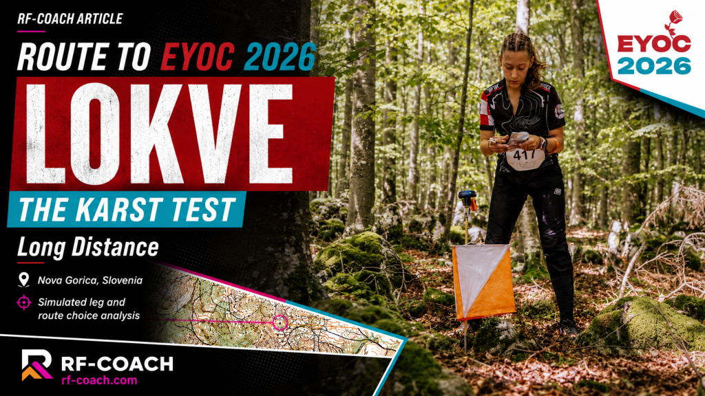
This is the kind of terrain where a good result will not come only from running fast. Lokve is hilly, demanding and technically rich, with significant climb, karst formations, stony areas, steep slopes and deep depressions. The forest may allow high speed in many sections, but that is exactly what makes the challenge so interesting: athletes will need to run offensively while keeping full control of the map, the compass and the terrain.
The key to this long distance will be simplification. Karst terrain often offers too much information: depressions, small hills, broken contour shapes and similar features repeated across the forest. Trying to read everything is impossible at race speed. The best athletes will first understand the big picture: slope direction, main depressions, ridges, runnable areas and safe attackpoints. Only then will they use the smaller details where precision is required. Route choice will be central. In this terrain, the shortest line will not always be the fastest one. Every leg must be judged through a combination of distance, climb, runnability, technical risk and quality of execution. A longer route with better flow and a safer control approach can easily beat a direct line through heavy climb, stones and complex depressions.
The biggest danger will probably come from overconfidence. Good visibility and runnable forest can tempt athletes to increase speed too early. But in karst terrain, small compass errors or small misunderstandings of the contours can quickly lead to parallel mistakes. The right principle is simple: push hard when the picture is clear, slow down when the terrain demands precision. Control approaches will be decisive. Many mistakes in this type of terrain happen not because the route choice was wrong, but because the final part of the leg was not planned well enough. Before attacking the control, the athlete needs a clear attackpoint, a precise direction, an expected terrain picture and a way to stop if something does not fit.
The long distance in Lokve will reward complete orienteers: athletes who can manage climb, stay calm under pressure, simplify complex terrain and make good decisions while tired. It will not be a race for blind push, but neither for passive running. The best performances will come from controlled offensiveness: brave route choices, clean execution and full focus in the decisive moments.
🧠 Simulated Leg for the Long Distance
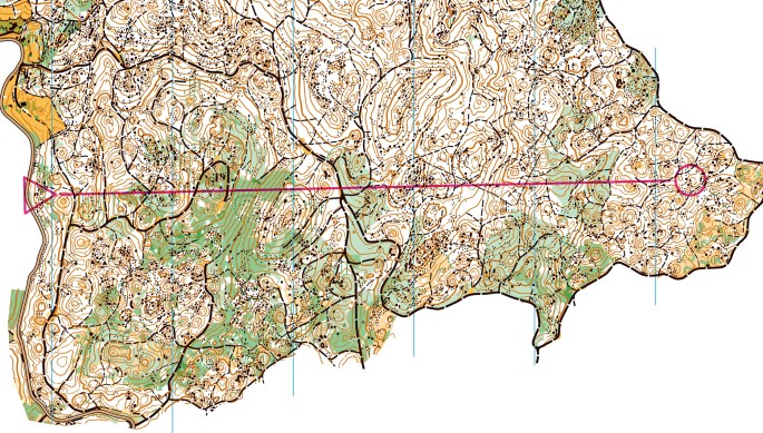
As part of the preparation for EYOC 2026, I have created a simulated long-distance leg inspired by the type of challenge athletes may face in Lokve. This terrain will demand much more than running speed. Significant climb, karst shapes, stony ground, steep slopes and deep depressions will force athletes to make smart route choices and execute them with full control.
The key question is not only which route is shortest. It is which route gives the best balance between speed, climb, safety and execution. A direct line may look attractive, but it can quickly become risky if the terrain is complex or the control approach is unclear. Tip!! At EYOC level, the best decision is often the one you can understand, trust and execute under pressure.
➡️ Your task:
Take a close look at the map below. Draw your route and imagine seeing this leg during the EYOC long distance, with tired legs and limited time to decide. Where can you run fast? Where do you need precision? And how will you attack the control without losing map contact?
SPOILER ALERT!!!
If you haven’t drawn your route yet, do not keep scrolling down!!!
The analysis of the routes is posted just below!!!
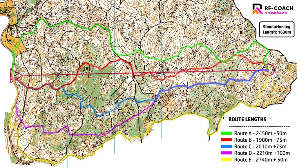
After presenting this simulated long-distance leg from Lokve, it is time to look at the route choice. I identified five main options, ordered from north to south:
Route A: 2450 m, +50 m
Route B: 1980 m, +75 m
Route C: 2010 m, +75 m
Route D: 2210 m, +100 m
Route E: 2740 m, +50 m
The straight-line distance is 1630 m, so this is not a leg to leave without a plan. Route choice matters here. A few extra seconds of analysis can save much more later, but overthinking is also dangerous. The key is to understand the balance between distance, climb, surface and technical risk. In this terrain, a large part of the leg will be executed on paths, small tracks or wider forest roads. That means the speed can be high, even on a long leg. The real question is how much extra distance you are willing to accept in exchange for simpler execution.
- Route E is the easiest to execute, but it is too long. At 2740 m, it adds 1110 m compared with the straight line, around 68% extra distance. That is too much to justify at this level, even if the running is fast and simple.
- Route C is reasonable on paper, around 23% longer than the straight line, but the execution is not clean enough. Too many transitions, too many small decisions, too much risk of losing rhythm.
- Route D is also possible, but not optimal. It is about 36% longer than the straight line, adds the most climb, and shares some of the same issues as C in the second half.
That leaves A and B as the most interesting options.
- Route A is longer, around 50% extra distance, but it connects paths and tracks very well and keeps the execution simple. For a physically strong runner with slightly less confidence in this terrain, it can be a very strong choice: stable rhythm, low cognitive load and limited technical exposure.
- Route B is my preferred option for the best split. It is the shortest route, only around 21% longer than the straight line, and offers the best balance between distance and speed. The price is that the second half requires precision. If you choose B, you must stay sharp all the way. The route is fast, but only if it is executed cleanly.
My ranking for split victory would be: B, A, C, D, E
The main lesson is clear: the best route is not always the safest, the shortest or the easiest. It is the one that gives the best balance for the athlete who has to execute it under race pressure. For a technically confident runner, B is the route to beat. For a strong runner looking for control and rhythm, A is a very good alternative. For everyone else, the danger is choosing a route that looks comfortable, but pays too much in distance, climb or technical interruptions.
Final Thoughts
At EYOC level, long distance is not only about choosing routes. It is about managing the whole race under pressure: reading enough, but not too much; simplifying without becoming passive; committing to a plan without losing flexibility; and understanding that a clean solution executed with confidence is often better than a perfect route found too late.
That is why Lokve will become one of the most challenging races of EYOC 2026. The terrain will be physical, with climb, stony ground and demanding slopes, but the biggest differences may come from how athletes handle the technical stress. The best runners will not simply be those who push hardest. They will be those who can manage the effort, read the karst clearly, protect the control approaches and keep map contact when the forest allows high speed.
The long distance in Lokve has all the ingredients of a proper championship race. It will reward athletes who know themselves, trust their process and make every decision count.
Enjoyed this article? 🧭
Share it with someone who loves orienteering, training and performance. 🚀
And if there is a topic you would like to see next on RF-COACH, feel free to contact me. 💬
Discover more from RF-COACH
Subscribe to get the latest posts sent to your email.

