
There are only 22 days left until the first round of the World Cup in Østfold (Norway) kicks off, and only now the snow has melted after a long, and cold winter.
As an aid in the theoretical preparation, I will publish a series of relevant legs on the old maps of the competition areas, so that after analyzing the leg, the athlete can draw his theoretical route and add the comments he/she considers interesting. An analysis of the suggested routes will be published afterward.
LONG LEG AT TOREBRÅTE (#1)
One of the biggest challenges that the Østfold terrain offers is being able to anticipate what we can expect in terms of runnability and visibility in the different areas. As a general rule (of course subject to exceptions), we could say:
- The tops offer better visibility and runnability than the lower areas.
- Running following the contour line on medium/steep slopes is usually slow.
- Semiopen areas often offer good visibility but poor runnability.
- Light green is usually good in runnability but with reduced visibility.
- Avoid green lines.
Now you can analyze this leg, and draw your optimal route by pressing the button below. Please, add your thoughts as comments 🙂

ANALYSIS OF THE ROUTE-CHOICES
It is always difficult to establish the best route-choice in a leg which runners have not run. The best route-choice in each leg is largely determined by the physical-technical qualities of each runner. However, we can carry out an analysis of the main obstacles and areas of low runnability that we should preferably avoid.
At a cursory glance at the leg, it may seem to us that the first hill is too high to run straight, however, looking a little closer we can see that it only involves two extra contour lines to the top.
We find several areas (marked in red) where runnability is going to be significantly reduced due to terrain formations and which we should preferably avoid. The semi-open terrain is usually a little bit unknown in terms of runnability and can be a fast surface with easy progression or, often, somewhat rough and with an uneven surface that does not allow us to run comfortably. This is one of the main handicaps in this area, a result that is difficult to predict.

After analyzing the almost 100 routes drawn the previous days, we can establish up to 5 “viable” options to execute this leg.
- Straight route (1135m): It is the most offensive option running directly to the first hill. The biggest drawback is that in this case, you have to run a considerable section in the semi-open, which can slow you down. It is the perfect option for runners with strength and experience on this type of terrain.
- Right route (1215m): Choosing the route on the right it is possible to save 2-3 contours by doing, in return, a few meters (80) extra. Once you reach the highest point, good precision is required when dropping diagonally down, crossing an area of low visibility to use the small path that leads to the semi-open. It can be a good route for runners who are not so powerful, but with good technique.
- Left route (1270m): The left route is 135m longer than the straight route, but it avoids low runnability areas (except for the final part). It is a safer route than the previous ones, but it is not as effective.
- “Very” right route (1305m): If you take the route to the right, it’s possible to run a variation and run up the path for an easier attack on control. It is a good option for the more “runners”.
- “Very” left route (1625m): It is the most defensive option, almost 35% extra than the straight option, which seems like a lot to consider it a winning option.
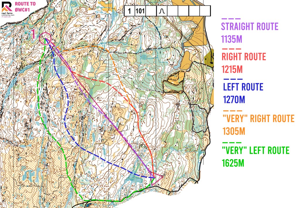
So we could conclude that probably the best option would be the straight option for strong orienteers (especially in the men’s class), and one of the right options for those looking for a more defensive option (especially in the women’s class).
Did you like the content? You can buy me a cup of coffee 😉
Discover more from RF-COACH
Subscribe to get the latest posts sent to your email.

2 thoughts on “Route to World Cup #1 (with analysis)”